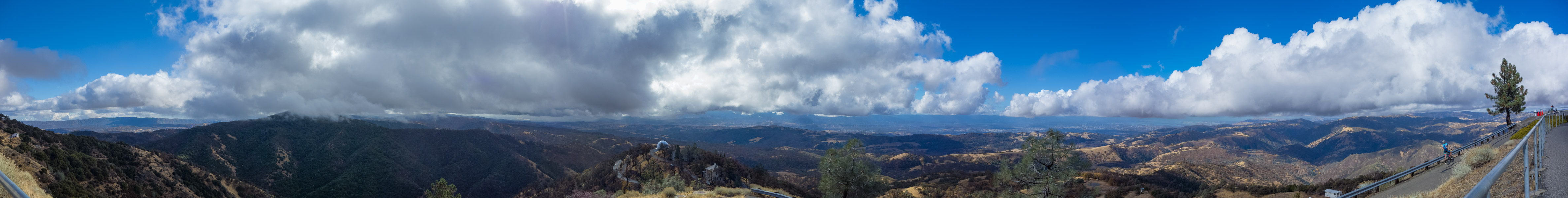
Mount Hamilton Panorama - 11/2018
Reload page to see different photo.

All web site content except where otherwise noted: ©2025 Bill Bushnell
Background texture courtesy of Iridia's Backgrounds.
Please send comments or questions to the .
Bike Items for Sale - Here's a photo journal of bike parts that I'm trying to clear out of my workshop.
Shipping is $10 or (actual shipping charges + (optional) insurance charges + delivery confirmation fee), whichever is greater. I will try to find cheapest shipping option (e.g. USPS for US Domestic delivery) or will ship according to your carrier of preference.
Some of the parts are new, some are used. If you think my item pricing is off or you're buying multiple items, please make me an offer.
I am selling everything "as is". But, if you buy an item that is dead on arrival, damaged in shipment, or you believe you got a raw deal, please contact me as soon as possible so we can work out a solution. Given the time involved in selling these items I am not making a profit on this and am more interested in seeing components and parts I no longer use but that have remaining useful life to find a home with other bicycle enthusiasts, where they will be used instead of collecting dust in my workshop.
Contact me at the following . It will help if you include the links to photos of the items that interest you. All prices are in US Dollars.
Entire Blog - Display the entire Blog for all years. This is a large file!
| Bike Ridden: | Rotator Pursuit |
|---|---|
| Distance: | 91.4 miles |
| Cumulative climbing: | 5250 feet |
| Total Time: | 5:29:43 |
| Riding Time: | 4:53:16 |
| Avg. Speed (moving): | 18.7 mph |
| Max. Speed: | 56.5 mph |
High Sierra Fall Century, September 13, 2003 - On our first full day in the mountains I rode the High Sierra Fall Century. This was the first year I rode my new Rotator Pursuit with F1 fairing.
My route took me out of the condo and up toward Mammoth Mountain and the start of the "scenic loop" drive (actually an alternate escape route in case the town needs to be evacuated). The Scenic Loop road had rather severe frost heaves that made the ride bumpy, even with the springy suspension on the Pursuit.
When I got to US395 I turned left and joined the official ride. I continued over a couple of low hills and across a wide valley before stopping briefly at Crestview rest stop.
The next couple miles was a climb to Deadman Summit before crossing into the Mono Lake Basin, where I had a wonderful downhill run at speeds well into the 40's (mph). At the bottom of this long downgrade I turned right onto CA120 and headed east toward Mono Lake.
I continued past the Mono Lake Rest stop and pressed on up the gradual climb to Sagehen Summit. The eastern side of Sagehen Summit has another nice, fast, sometimes scary, descent. I was able to coast all the way to the bottom at the right-hand bend where the highway starts its long undulating trek across Adobe Valley.
I stopped at the lunch stop and ate some of the provided lunch--I wanted to try to get my money's worth. By this point I was with the early group, and staff were just getting lunch set up.
After lunch I continued down Adobe Valley and then turned right on Benton Crossing Rd without stopping at the rest stop at the junction. The climb up to Wildrose Summit is my least favorite. For some reason this road looks not as steep as it is, and it seems to go on forever. Maybe, too, I am usually starting to get tired by this point. The road also gets steeper as it approaches the summit, amplifying the effect of fatigue.
I continued past the drink stop--should've stopped and had a drink--and continued down into the valley near Moran Spring before climbing gradually again to Watterson Summit, where I did stop. I was getting tired by this point, but I felt it best to press on to the finish with minimal delay as I was having a fast day on the bike.
I continued down Watterson Canyon and then the last ten miles around the north side of Lake Crowley into a gusty wind. By the time I finished I was feeling pretty beaten up. I had thought to ride back up the hill to the condo, completing 100 miles total, but I decided, after eating the end-of-ride meal, to take David up on his offer to come pick me up at the finishing area.
Overall it was a good ride in nice weather, but I had ridden hard, and as it turns out, I would be tired on the next few days of our trip.
Bountiful Ridge, June 25, 2003 - After driving south all morning from Idaho Falls we arrived in Salt Lake City at mid-day. David and Kay wanted to spend time at the Geneology Library, but I wanted to get outside and enjoy the pleasant weather. So, they went to the library, and I got on my bike and explored the hills east of Bountiful, UT.
From the Days Inn on North Temple St. I rode uphill toward the center of town. At North Main St. I turned left and continued uphill to Victory Rd. After cresting the top of the hill I descended into Bountiful on Beck St. then Orchard Drive. I rode Orchard Drive north through Bountiful until I reached E 400 N. I then turned right and began climbing again.
The map I had with me did not include many details. I was looking for Skyline Drive, but it did not connect to E400N by that name. So, it was with some trial and error that I found my way to Skyline Drive, after riding up the hill as far as the Bountiful Temple. N1300E turns out to have been the connection.
Shortly after passing through the newest subdivision high on the hill, Skyline Drive turns to dirt, passing what looks like a makeshift dirt-bike play area and within earshot of a local gun range.
Skyline Drive climbs gradually but relentlessly to the top of the range directly east of Bountiful and Salt Lake City. The road is open to auto traffic, and a few motor vehicles and dirt bikes passed in both directions, but traffic, fortunately, was light.
I eventually reached the summit of the ridge where I enjoyed a breathtaking view of the Salt Lake Valley to the west and the corrugated land of the Wasatch Range to the east. My plan was to have continued on Skyline Drive, climbing another 1000 feet under the nose of Bountiful Peak before starting a long descent through Farmington Canyon, exiting in Farmington, about 7 miles north of Bountiful on the same side of the mountains.
Unfortunately, I had started my ride too late to risk continuing. If I found myself stuck by road closure or mechanical breakdown I might be stuck in the mountains overnight. Plus I had agreed to meet David and Kay for dinner that evening, and I didn't want them to worry.
So, I took my photos and then descended the way I had come. But, instead of returning past Temple Square in Salt Lake City, I rode downhill and west to Redwood Rd. before turning south and returning to the hotel.
| Bike Ridden: | Gold Rush |
|---|---|
| Distance: | 124.6 miles |
| Cumulative climbing: | 8000 feet |
| Total Time: | 9:32:32 |
| Riding Time: | 8:01:00 |
| Avg. Speed (moving): | 15.5 mph |
| Max. Speed: | 47.6 mph |
Mount Hamilton Challenge, April 26, 2003 - I woke up at 0430 so as to get a 0600 start. Pouring rain. Went back to bed. Woke up again at the reasonable hour of 0700. Got ready to go and was on the road at 0845. Riding with haste I took the shortest route to Mt. Hamilton Road and was on my way up the first of the three climbs by 0930.
The weather was cool with a pungent freshness in the air. Puffy clouds could be seen over the mountains, but none looked dark enough to hold rain. All the greenery was damp from the rains of the night before, but the roads were dry. I saw a surprising number of cyclists on the road, many of them on the Challenge or Ascent ride. They must have been late-starters as I was. I paused once to pee and peel, but otherwise I continued to the summit without stopping or getting off the bike. On the way I saw several different kinds of Lupine, a couple of large hawks circling slowly over the middle ridge, but no four-footed wildlife. I arrived at the summit shortly before noon, about three hours from home. Don Bennett was resting against the wall of the post office.
I also saw Bill, whom I SAGged on the Low-Key Mr. Bill’s Nightmare ride in 1996. He remembers the occasion better than I, recalling my old 1971 Buick that I have since sold.
I filled up on water, did some stretches, and was on my way down the back side by 1215. Don Bennett was behind me at the top, but I didn’t see him again until later in the ride. The first half of the backside descent was crap. Another cheap tar and gravel job from the county roads department. No attempt had been made to grade the scooped and washboarded surface of the roadway where autos brake before the hairpins, making these spots particularly hazardous when leaning to turn on a single-track vehicle. I was dragging my brakes all the way down the hill, following most of the way an SUV who passed me before at the top. I was hoping that my tires wouldn’t blow with all the heat I was dumping into the rims.
At the bottom of the hill I kept moving across the Isabel Creek Bridge, almost touching my front wheel to the SUV’s rear bumper until it roared ahead up the next hill. Along this southern-most section of San Antonio Valley Road in the rain shadow of Mount Hamilton where the road passes through treeless, twisted, and tortured hills, reminiscent more of the hills of southern California than of those of the north, I passed Bill and Company and a couple of tandems
The color of many wildflowers splashed the meadows of Upper and Lower San Antonio Valley. A few motorists were parked along the road taking pictures. Some had medium format cameras. As I made my way north toward The Junction I began to see the first of the Devil Mtn. Double riders passing in the opposite direction, maybe 10 altogether before The Junction. I continued past The Junction since I hadn’t planned to stop again until Livermore. I could see that the parking lot of the cafe was full of motorcyclists and bicyclists. I saw Craig Robertson about 1/4 mile north of the junction, riding south, alone, and looking grim.
As I crossed a cattle grate just before the first major summit a few miles north of The Junction, I felt the front of the bike go “BANG-BANG-BANG...”. Now, usually, crossing a cattle grate gives a “bump-bump-bump...” sound, but this time it sounded like metal on metal. The front tire looked O.K., but I was worried that it may have been going soft. I dragged the front brake. Fortunately I hadn’t dinged the rim.
At the top of this summit is a nice big turnout, so I pulled off, got out of the bike and checked things over. Turns out both front and rear tires were soft. So, I took out my tools, found a comfortable mound to sit upon, and got to work.
Front tire: looked like a pin prick, probably from glass or a thorn, but I could find neither in the tire. Since it isn’t thorn season, it was probably glass. Rear tire: glass. I found the offending piece in the tire.
While I was working on my flats was able to observe a parade of cyclists passing in both directions. I saw most of the cyclists I had seen earlier in the ride including Don Bennett, Bill and company, Ken Holloway and Paul Guttenburg (going south), Lee Mitchell (driving SAG) going south, and Ken Straub and Lisa Antonino, whom I had not yet seen on the ride, going north, who stopped to chat. They had stopped to eat hot dogs at The Junction cafe. Pictures were taken, GPS coordinates were checked (The nearest item of interest appeared to be a rest stop on I-5.), and cell phones were tested.
As I was struggling to remount my rear tire, a SAG van from the Hamilton Challenge stopped to offer help. Fortunately, I accepted the offer as it took two of us with two VAR tire tools to remount my rear tire. (Avocet City on a Ritchey OCR Comp rim) This was the first flat I had on this tire, and the first since last August or September–I can’t remember how long it had been since I had a flat, and today I get two!
A half-hour later I got back on the road, and after climbing the last bump over Eylar Ridge, I began the long gradual descent into Livermore, crossing two rushing fords on the way down, the first of which seemed deep enough that hitting the water at 30 mph seemed like a Bad Idea.
In Livermore I stopped briefly at the softball field at Wente Road and South Livermore Avenue to refill water and then continued on the direct path through downtown Livermore to Pleasanton. My original plan was to stop at a sandwich shop to eat a proper lunch, but the hour late (1530), and a sit-down lunch would have killed at least 45 minutes, perhaps more, since riding on real food would have slowed me down, at least for a while. I was still about 3 hours from home. So, I pressed on, noting for the future the location of the Togo’s and Subway sandwich shops.
The gradual downhill on Stanley Blvd. was offset by the constant headwind. The road was lightly traveled and the shoulder broad and clean. Even the abandoned track that crosses the boulevard midway between Livermore and Pleasanton, quite hazardous in years past, had been paved so that only the top of the rail was visible. On the nearby railroad tracks to the right, a long Union Pacific freight train with 4 or 5 locomotives was grinding slowly toward Livermore and Altamont Pass.
At Bernal Road and Pleasanton-Sunol Road I regained the official Challenge route and continued on to Sunol. A group of rail workers, probably connected to the tourist train out of Sunol that uses the old SP right-of-way, who were working the track, waved as I rode by. As I passed the small store at Sunol Corner, the idea of enduring the next 15 miles of Calaveras Road on naught but energy bars, biker goo, and water seemed unbearable. I needed some real food. So, I turned around, rode back, and bought a V8, a bag of potato chips, and a 20 oz. Sprite.
On Calaveras Road I seemed to have fallen in with a different, more intense group of cyclists than I had seen earlier. On the first climb, John Langbein caught up to me, and we chatted for a while. John had seen another cyclist a few miles back on a socked Gold Rush and had thought it was I. One guy wearing a Sun jersey, out of a group of three I had passed earlier, also caught up. For a while the three of us rode together trading positions depending on the terrain. On the downhills I’d get ahead, and then get caught and passed on the uphills. At some point, John dropped off, I think, to take a roadside break. Along this stretch I again saw Lee Mitchell driving SAG for the DMD and Craig Robertson, who appeared to have found a group to ride with and who managed a smile as we passed.
At the southern end of Calaveras Road where the land opens up a number of cyclists were passing in both directions. I also saw (for the second time) the same green Subaru driving SAG on the DMD. The driver gave me a thumbs up. Just before the top of the Calaveras Wall I caught up to “Sun jersey”. The descent into Milpitas was furious and short. I braked so hard at the stop sign at Piedmont that I nearly got thrown forward off my seat. I took Calaveras to South Temple, then to Yosemite, South Milpitas Blvd, Montague Expressway, Trimble, and Central Expressway. Back in the city motorists rushed to get nowhere important, especially at the freeway on/off ramps. But I only noticed this because motorists had been unusually polite on the rest of the ride.
I arrived home at 1815, nine and a half hours altogether, 8 hours of riding time for a total of 124.6 miles with 8000 feet of climbing. This was the first time I had taken the bike with the hard fairing up and over Mount Hamilton, the fully-outfitted (water, food, clothes, etc.) weight of which falls somewhere between 55 and 60 pounds. In my haste to leave home I had forgotten a windbreaker/jacket, but it turns out I didn’t need it. In fact I was in short sleeves for all but the top of Mount Hamilton and the backside descent and for my extended flat-fixing break. In all, an excellent ride, with perfect weather, cool with mixed overcast and sun.
Cherry Pie Criterium, February 2003 - One of the few criteriums in the country (Napa, California) that has a recumbent class.
Winter Solstice Century, January 2003 - A Bikeaholics ride from Gilroy, California south to Pinnacles National Monument and back.
All web site content except where otherwise noted: ©2025 Bill Bushnell
Background texture courtesy of Iridia's Backgrounds.
Please send comments or questions to the .