
Deer Valley - 5/2005
Reload page to see different photo.

All web site content except where otherwise noted: ©2026 Bill Bushnell
Background texture courtesy of Iridia's Backgrounds.
Please send comments or questions to the .
Our lives get busier and further constrained as we get older. Shouldn't it be otherwise? This year several events converged to put at risk our plans for a trip to the Sierra Nevada Mountains near Mammoth Lakes.
First it was Frank and Stella's cat, Spartacus, who presented last month with a mysterious injury to his tail that led to his apparent depression, lack of appetite, and random indoor urination. Then my bedridden father's late diagnosis of pneumonia followed by COVID (2nd bout), then a limited window of availability for Frank and Stella's cat-sitter who as a veterinary technician was uniquely able to care for an injured Spartacus during our week's absence.
Somehow it all came together. The day before we left I made the condo reservation, we packed our things, Frank made arrangements with our guide, Jo, for a day of outdoor top-rope climbing, we departed for our trip, and hoped none of us would be called home early.
| GPS track: | GPX |
|---|---|
| Distance: | 2.6 miles |
| Cumulative climbing: | 1490 feet |
| Total Time: | 3:44:48 |
| Hiking Time: | 1:32:45 |
Gaylor Peak, September 10, 2026 - For our first day in the Mountains we had difficulty deciding where to start. We knew we didn't want to return to Lookout Peak after Stella's twisted ankle last year on the talus around Ruby Lake, and we had climbed Reversed Peak three times now in as many years, so it seemed appropriate to look for a different starting hike. We settled on Gaylor Peak with the add-on bonus of descending the Class 3 north ridge as we had in 2013.
After eating breakfast and making our final preparations we piled ourselves into Frank and Stella's car for the drive up to Tioga Pass. Although the morning was late by the time we arrived, the queue at the Pass was fewer than five vehicles. Soon we were inside Yosemite National Park, and we promptly found a parking space in the small lot next to the entrance station. The trail to Gaylor Lakes and Peak starts from this parking lot.
Our last hike here had been in 2013, and for Stella that would be 2007, since she didn't join us in 2013. Memory has a way of softening the hard parts. I knew the trail started up a short but steep slope to the pass separating Tioga Pass from Gaylor Lakes, but I had neglected to consider this was our first hike at altitude and that we were 10-20 years older than at our prior visit. Soon we were all breathing hard and hiking slowly. Ugh!
At some length we reached the pass where we took a short break before starting up toward the Peak itself, a short distance to the north along the ridge.
The terrain leading to the Peak starts easily and gradually, but as we drew closer the grade increased and the terrain became rockier. Soon we were climbing up clinkers, mostly metamorphic rocks between the size of scree and talus that move under foot, making a characteristic "Clink!" noise with each step. A faint use trail was visible most of the time, but near the summit we merely chose what appeared to be the easiest route across the rocks.
From the summit we enjoyed the surrounding view. Although Gaylor Peak is not particularly high, standing just above 11,000 feet, it affords a nice view east of Tioga Pass, the Kuna Crest to the south and Tuolumne Meadows and the Cathedral Range to the southwest. We spent some time here.
As we prepared to depart, Frank and Stella were no longer enthusiastic about descending the north ridge. We were mindful not to wear ourselves out the day before our guided top-rope climbing day with Jo tomorrow. Nevertheless I explored north along the ridge and descended some distance to make a report to Frank and Stella so that they could decide whether it was worth continuing on our planned loop down the north ridge, then return to the Gaylor Lakes Trail before heading back to the trailhead.
I went as far down the north ridge that was Class 2, then saw that I'd have to fold my hiking poles to continue further. By then Frank and Stella chose to return the way we had come. Since I didn't want to wear myself out I was OK with that, so I climbed back to the Peak and then followed them down to the Pass along much the same route we had taken up the Peak.
At the pass we paused again before continuing down the steep trail. We stopped at a large rock with a nice view of Mount Dana where we ate our lunches and watched a number of hiking parties go past.
After lunch we continued another five minutes down the trail to the trailhead.
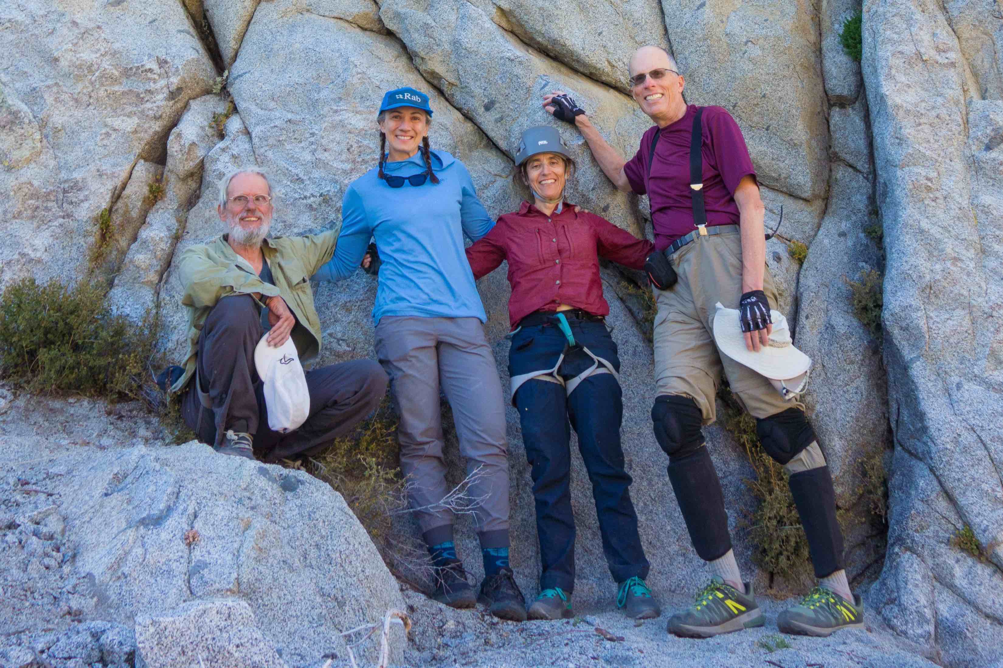
Group photo after our climbing session. (L to R): Frank, Jo (our guide), Stella, and Bill
| Distance: | 1.2 miles |
|---|---|
| Cumulative climbing: | 1400 feet |
| Total Time: | 7:46:49 |
| Hiking Time: | 0:31:29 |
Climbing, September 11, 2026 - Today was a big day in our week. Frank had hired Jo, our climbing guide of prior years, to show us a new climbing area somewhere between Bishop and Mammoth that was yet neither published online nor in any guide book (hence my suppressing the actual location of our climbing spot in this blog, for now).
We met Jo and her friend, Cara, near US-395 before caravanning to the actual site whereupon we assembled our gear and began our short but steep hike up to the base of the wall on which we would be climbing for the rest of the day. Cara would be helping Jo set up the top-roped routes we would climb today so that none of us would be required to lead-climb or lead-belay.
The hike up the steep slope was similar to that of last year's Gong Show approach, the main difference being that we only carried one pack on each of our backs, although we did carry a few extra items of climbing gear such as our helmets, shoes, PAS, extra carabiners and slings, and a few draws.
When we had arrived at the climbing site, Jo and Cara went to work setting up the first route's top-rope. The route was slightly higher than what we have experienced at the gym. As with most outdoor routes we have climbed, the wall before us was mostly slab with many tiny crimps and jibs for hands and feet. A few good holds could be seen here and there, and in a few spots a crack might be put to use.
Whether it was because I was feeling good today or because the route was graded 5.7, or because it looked easy as I watched Jo climb it, I volunteered to climb first.
Unlike in the gym, there are no color-coded holds that guide the way. And because these routes were newly bolted, the good hand holds showed no hint of chalk dust. We had to read the route for ourselves.
I started up to the left toward a large crack/chimney that appeared to offer better holds for my large feet. This strategy seemed to work well until I got about halfway up. At that point Jo suggested I move to the right and onto the face of the wall itself. I was dubious at first because all possible hand and foot holds looked tiny. But, I could see that climbing further up the crack would require me to get past a few shrubs and the higher I climbed the more off-center my top-rope became, which would lead to a significant pendulum fall in the likely event that I came off.
I did as I was told and somehow my feet and fingers held on. I thought I might get to the top without coming off, but about 2/3 of the way up my fingers fatigued to the point where I couldn't hold on and I came off swinging slightly back towards the aforementioned crack.
After getting back on I managed to climb the rest of the way without coming off again. I was rather pleased to reach the top.
Next was Stella's turn. She started much the same way as I, but she slowly and surely and with surprising confidence made her way to the top without coming off, flashing the route.
Then Frank made a go, reaching the top after coming off once when he got too far off-route onto some crumbly rock to the right of the route.
Jo and Cara then moved the top-rope to another route nearby. This second route was rated 5.8 and started up a deep and wide crack. This crack was almost wide enough to be a chimney. One could climb it gripping holds inside the crack rather than using crack-climbing technique. The route reaches a ledge that marks the half-way point. I watched Jo surmount the ledge using two opposing under-clings and made a mental note to try the same method.
The upper wall featured few good holds, offering mostly crimps and jibs even smaller than on the first 5.7 route we climbed. I suppose this route had to be harder to earn its higher rating.
As I started up I found the lower crack/chimney pretty straightforward. The hand holds in the chimney were decent, and its left edge had some decent holds for feet.
At the top of the crack one needs to make a transition to the left before hoisting oneself up to the halfway ledge. I made the lateral moves using a couple of hand holds Jo had pointed out when she climbed to set up the top-rope. But, before I could pull myself onto the halfway ledge I came off. I can't recall if it was fatigue or if I just mis-read how to proceed. After a short hang-dog rest, I got back on and found the underclings that Jo had used and got myself up to the ledge where I shook out and rested before starting on the head wall.
The upper wall looked more promising from the ground. The lower part of the headwall wasn't too difficult. There was even a nice ledge part-way up. But as I approached the anchor the holds got smaller and less viable. I came off a few more times on the upper half of the headwall as I tried a few different ways to proceed, but I eventually reached the top. Fatigue may have been a factor by this point.
Then it was Stella's turn. She came off on the transition halfway up but had an easier time on the headwall than I had.
Then Frank made a go and flashed the route.
After we had each climbed the first two routes, we took a lunch break while Jo and Cara set up two more taller routes on a part of the wall further to the left. These routes would require some honest crack-climbing technique. Unfortunately, we only had enough time and energy to climb what we thought was the easier of the two routes.
This time I let Frank climb first so that I could learn by watching him.
This third route features two long cracks, one from the bottom to about 2/3 of the way up. A nice deep ledge is reached for a rest. Then a tricky transition to the right is required before climbing the upper crack to the anchor. The crux move is apparently getting past a bulge in the wall along the upper crack just before one reaches the anchor.
All of us managed to get most of the way up the lower crack before coming off at least once near the top while we struggled to find a way onto the deep ledge. Then we all came off multiple times on the transition to the right or while attempting to climb the upper crack. But, we all topped out after our struggles, and this was a victory in my mind.
None of us had done crack climbing before. Only Frank had a pair of crack-climbing gloves, and while they fit Frank's hands well enough, they were a very tight fit on my hands, and probably a bit loose on Stella's. I would not have attempted the route without some sort of protection on the backs of my hands.
I learned how to use my hand/fist as a cam in a crack and trust the resulting cam effect well enough to pull my body weight on it. On this route the crack was very deep, so it was necessary to reach my entire arm into the crack once or twice. I also learned to jam the toe of my climbing shoe into a crack and twist it so that it was held fast by the rock. And my climbing shoes are now showing extra wear around the toebox for it.
After we had all reached the top of the third route, it was hard to believe we had spent six hours at the foot of this wall. Now it was time to pack up our gear and make our way down the rough use trail. Once the ropes, anchors, and quick-draws were off the wall, Cara took off down the trail ahead of us and headed home.
At first Stella thought she had lost a pack strap, so we spent some time searching around before Stella discovered she had been sitting on it, bringing on a wave of relief mixed with slight frustration from not checking the obvious.
The mostly Class 2 use trail leading to the climbing wall is where I appeared to have some speed advantage with my long legs and large feet. Jo instructed me to keep going ahead of her, so I did as I was told and continued down at what I thought was a slow deliberate pace.
At some point I looked back and could not see the others. I paused, then saw that I wasn't too far from the bottom of the hill, so I resumed. A moment later I heard Jo's voice high above calling me, and Frank shortly after that radioed me not to get too far ahead. So, I waited at a spot where I could sit and rest rather than stand precariously on the steep slope.
When we were all together again, I resumed my descent, again waiting to regroup before attempting the creek crossing on the logs.
We all got across the creek without incident, and from there we had a trivial walk back to the van.
After packing up, changing shoes, and dropping Jo off at her car near US-395, we returned to Mammoth for showers and dinner, a successful day outdoors accomplished.
| GPS track: | GPX |
|---|---|
| Distance: | 1.4 miles |
| Cumulative climbing: | 110 feet |
| Total Time: | 0:37:36 |
| Hiking Time: | 0:36:28 |
Meadow Walk, September 12, 2026 - After our big climbing day we took our rest day today. We didn't do much other than nap, read, and bury ourselves in our laptops, tablets, or phones. Meanwhile a wind blew outside, making our decision to remain indoors easier.
Then late in the afternoon the wind died down, and the light of the sun lower in the sky shining through the meadow grasses that we could see through our living room window invited us to get outside briefly to enjoy this quiet time of day.
Suddenly I felt like moving, so I suggested we take a short walk through the meadow just beyond our window before starting dinner. This was agreed albeit somewhat reluctantly and then only after a brief but frantic search for Stella's apparently missing orthotic insoles. We found them where she had last used them.
At first we walked along the edge of the manicured lawn at the Snowcreek complex. We walked east almost to Minaret Road before crossing a tributary of Mammoth Creek and walking west, back toward home, through the natural meadow.
We walked as far as the bridge connecting the north and south ends of Waterford Avenue before circling back into the Snowcreek complex and home.
| GPS track: | GPX |
|---|---|
| Bike Ridden: | Power Gold Rush |
| Distance: | 110.3 miles |
| Cumulative climbing: | 13,760 feet |
| Total Time: | 6:52:14 |
| Riding Time: | 6:03:46 |
| Avg. Speed (moving): | 18.2 mph |
| Max. Speed: | 28.7 mph |
| Wh/mi: | 14.6 |
Round Valley Out and Backs, September 13, 2026 - Aside from enjoying a week in the mountains hiking and climbing with Frank and Stella, my other goal for the week was to bring my bike and ride these out-and-back climbs from Round Valley that I had never ridden before today.
A few years ago I had planned to start my ride in Mammoth, descending US-395 to Round Valley, doing the climbs, then riding back into Mammoth. That plan was about 150-160 miles, depending on where we ended up staying in Mammoth and on which routing options I chose. It would have required a full battery and an extra hour or two, and would have left me rather tired for the next day.
So, I modified my plan to start and end somewhere in Round Valley. I found this nice park just west of Bishop that offered water, flush toilets, and free all-day parking and would otherwise function nicely as a "home base" for this ride. This also gave me the option to cut the ride short if I ran out of time or into mechanical difficulty.
I left Mammoth at 0800 and after stopping in Bishop to fill up my gas tank with cheaper gas than one can find closer to Mammoth, I arrived at Millpond Park at 0920. A half hour later I got my bike out of the van and assembled for the day's tour and shortly thereafter commenced forthwith.
My route had me doing the Big Climb first: South Lake. This involved heading up CA168 and South Lake Road to just under 9700 feet, an elevation difference of about 5400 feet. Traffic was infrequent enough not to be annoying, even though the road was mostly shoulderless. Everyone passed leaving plenty of space.
On the climbs I made no effort to conserve battery energy so that I could finish my ride at a reasonable hour. I had another reason not to work too hard: The temperature was hot: 34C on my thermometer already! I also didn't want to be too tired for hikes over the next two days, not to mention having some energy for moving out of the condo in three days and driving home. My goal was to ride the roads, not to overwork myself into a state of dehydration or worse in the process.
After descending South Lake Road I wasn't finished with climbs in the area, so I turned left and visited Lake Sabrina, then detoured up the mostly dirt and gravel North Lake Road to the Piute Pass Trailhead. I hadn't visited this trailhead since 2013, the last year that Dad and the older generation of Mammoth hikers who got me started visiting the Mountains in 1992 had returned for one final send-off. That year we made one last visit in honor of Frank Brogan and Charles Rankin (with both of whom I had the honor of working early in my career) where we scattered the ashes of the latter at three distinct locations: San Joaquin Ridge, Mammoth Crest, and Upper Lamarck Lake.
The temperature at South Lake, Lake Sabrina, and North Lake was a warm but comfortable 22-24C. A stiff wind blew over the passes and down into Round Valley. This wind was most noticeable near the tops of all of the climbs and made initially for a quiet descent. I allowed my usual descending speed of 32kph to drift up to 40 or 45 kph. This would save some time and not cost extra energy due to the effective tailwind.
After enjoying a brief moment of nostalgia I returned down North Lake Road, then began the long descent of CA168 toward Bishop.
As I rode past my van at Millpond Park the thermometer had climbed back to 35C. I still had plenty of water on the bike and did not want to spend extra time in the heat at low elevation, so I continued past on Round Valley Road and began the second half of my ride of climbs at the western and northern side of Round Valley.
First of these was Pine Creek Road. I had never been up Pine Creek Road before today. Although I had studied the map, a visual inspection of the terrain ahead revealed no road passing into the deep valley ahead that I took for Pine Creek Canyon.
In the desert perspectives can be deceiving. What appeared from a distance to be a steep, roadless mouth of a deep canyon turned out to be a glacial moraine blocking my view of Pine Creek and its road. As I climbed up Pine Creek Road through Rovana it was clear to me where the road went and that the moraine I saw earlier appeared by illusion to be connected to the slope behind it, they both being covered by the same type of sagebrush vegetation.
Soon I was working my way up a pleasantly quiet Pine Creek Road. Although the road climbs gradually up to about 6800 feet, Pine Creek Canyon feels like a box canyon with its steep walls on either side, especially its imposing western side where I understand one can find many sport climbing routes. The head of the canyon features Pine Creek Pass Trailhead and an apparently dormant tungsten mining operation. From there all paths lead up in all directions.
Two days earlier Jo had suggested we check out a climbing area, "La Escuela", along Pine Creek Road. I found it not far from the Pine Creek Pass Trailhead, a modest segment of slab wall surmounted by a large semi-circular arch of rock. A couple were climbing on the rightmost part of the arch. I didn't stop to investigate further as it was still quite hot even 2500 feet above Round Valley. I checked my thermometer: 31C. It felt best to keep moving to maintain convective cooling.
I rode as far as the yellow gate marking the end of the driveable road. One faded sign on the gate read "Do Not Enter", but the signage said nothing about foot or bicycle traffic. The road leads past the mine, but there appeared to be no activity there. Moreover, the road is a direct continuation of the trail leading from Little Lakes Valley over Morgan Pass, and there were no signs at that pass on warning of no through passage, which I would have expected if someone really meant to keep the public out.
I decided not to explore further up the road past the gate mainly because I hadn't planned for time to do so, and I had one more climb to finish before returning to the van.
I descended Pine Creek Road at a moderate pace while letting the regen brake soak up all of the energy.
Once back in Round Valley I made my way northwest toward Old Sherwin Grade/Lower Rock Creek Road. This road climbs the shield of the old volcano formed by Long Valley. On the way it passes the community of Paradise, where it still felt hot as hell with the sun beating down. Higher on the climb the road passes Swall Meadows that lies on a spur road some distance west of the main road.
Here the road was smooth and gradual and the views behind me impressive. About 2/3 of the way up the road reached a high point before descending a short distance into Lower Rock Creek Canyon where trees and shade made the climbing relatively cooler. Eventually I came out at US-395 that I rode a short distance north to Tom's Place.
I briefly considered riding back to the condo in Mammoth and arriving early. It was about the same distance as returning to the van, although with some additional climbing instead of a nice long descent.
Frank had floated the idea of checking out La Escuela the next day, although I favored a short to moderate hike. I expected that Stella would vote with Frank for La Escuela. If that ended up being the plan then it would be easy for them to drop me at the van at Millpond on our way home.
One fly in that ointment was that Millpond day-use area was only open until 2200. I suspected my van would have been left undisturbed over one night, but I didn't want to risk having it towed in case the local authority were strict. Besides it was an easier ride for me to descend for the last 20 miles instead of doing a rolling climb into Mammoth from Tom's Place.
At this point I had ridden all major roads along the US-395 corridor between Lee Vining and Bishop. (I still need to check out a few between Lee Vining and Bridgeport.)
I retraced my route back and down into Round Valley. As with Pine Creek Road I enjoyed descending the smooth asphalt while the regen brake held my speed steady at 32kph so that I could enjoy the sweeping view into the valley below.
Instead of returning to my van on Round Valley Road I rode the shoulder of US-395 for a few miles, making for a much quicker if noisier return to Millpond. I arrived at just about 1700, the time I had planned to be back at the van so that I could return to Mammoth at a reasonable hour for dinner with Frank and Stella, who would have had their own adventure up Convict Canyon that day.
| GPS track: | GPX |
|---|---|
| Distance: | 4.8 miles |
| Cumulative climbing: | 1490 |
| Total Time: | 2:58:16 |
| Hiking Time: | 2:09:19 |
Pine Creek Canyon, September 14, 2026 - Today's outing has two parts: an attempted climbing day at La Escuela in the morning, and a short hike in the afternoon from Pine Creek Trailhead.
Part OneFollowing a short discussion the prior evening, we agreed to drive out to La Escuela along Pine Creek to check out what we assumed were easy routes that one or more of us would attempt to lead-climb. Frank for sure wanted to try this, and while I preferred to take a short hike instead, I was not against the idea of another climbing day. Although I had warned Frank and Stella that the weather had been quite warm in Pine Creek Canyon the day before, this news was not enough to dissuade them from checking out this climbing area. My thought was that if the climbing proved not to be as easy or as comfortable as we expected, we could easily alter plans to do a short to moderate hike from the nearby Pine Creek Trailhead.
The drive from Mammoth took just under an hour. We arrived while the wall was still in shadow. The temperature was cool enough for us to be comfortable in long sleeves. So much for uncomfortable heat.
We got our equipment out, including the Stick-Clip that Frank would use to place quick-draws on the lowest bolt or two of the route.
We started just to the left of a small tree that marked the bottom of one of the 5.5 routes. We could see the first two bolts, but above that was a section of Class 3 scrambling without bolts. We had trouble finding bolts on the wall above this section due to its distance from the ground. After much studying the wall we did find a couple of bolts, one quite far to the right and one quite far to the left of the second bolt, but we did not think these bolts were on this route but an adjacent route due to the lateral offset. (Lead climb routes can wander laterally more than a top-rope route.) It turns out the bolt to the right was on this route, but we didn't know that at the time. We thought we'd find the "correct" bolts for our route once Frank got into the Class 3 area where he could examine the wall more closely.
Stella volunteered to lead-belay while I stood nearby ready to help if needed and to take photos/video of our proceeding.
Frank easily got the rope onto a quick-draw installed on the lowest bolt, and from a stable stance next to the bottom bolt about six feet off the ground, we handed him the Stick-Clip so that he could clip the rope to the second bolt. He could effectively "top-rope" climb up to the bottom of the Class 3 scramble and avoid the risk of a ground fall should he slip on the lower wall.
Once he got even with the second bolt, he scrambled up through the Class 3 section to the base of the upper wall, looking for bolts on the wall above that were in-line with the two lowest. But, he found none.
He saw other bolts off to the side, but we all thought these weren't for our route since they were so far off to the side.
I was beginning to feel uneasy with Frank climbing so high above the second anchor. At his highest he was at least as high above the second bolt as the second bolt was above the ground. The rope would do him no good if he should slip.
With a great deal of frustration he reluctantly and carefully scrambled down to the second bolt and had Stella lower him to the comfortable stance from where he had earlier clipped to the second bolt. He tried to unclip the draw from that bolt but saw that he could not do that while his belay rope passing through that draw was under tension. So, Stella lowered him to the ground, and we shifted to an alternate recovery plan to retrieve our quick-draws.
Recovering the lower draw was easy. I spotted Frank as he climbed un-roped to the stance he had used earlier, and he manually retrieved that draw. Recovery of the quick-draw at the second bolt was less trivial.
I noticed off to the left that one could scramble up to a ledge that led directly to the top of the lower wall on our route. From there it might be possible to lean over the edge and manually un-clip the quick-draw now on the second bolt.
I volunteered to attempt this, but Frank insisted on retrieving the quick-draw himself. At this point he was un-roped, and until he was already at the top of the lower wall I did not notice he had removed his climbing helmet. I said nothing so that he wouldn't be further flustered by our climbing day that had become a bust.
Once he was just above the second bolt, he had just enough reach with his arm to unclip the quick-draw and let it fall to the ground. Then he carefully scrambled down the way he had climbed.
The outing reminded me a little of last year's first visit to Horseshoe Slab where we had almost lost a pricey cam in a crack at the top of the wall where we were practicing setting a trad. anchor. Not much climbing accomplished today, almost made an equipment "donation" to the wall, but we managed to recover it after some effort.
As Frank returned to the ground the sun began to poke into view over the top of the wall, and the temperature rose noticeably and rapidly. Photography would be horrible into the glare, and we were no longer in a mood to try a different route. So, we packed up our gear, tails between our legs, and returned to the car. "We failed La Escuela!", Frank exclaimed sardonically. But, the day wasn't in ruins.
Part TwoInstead of returning to the condo to sulk for the remainder of the day over our misadventure, we agreed to do a short hike from the Pine Creek Trailhead, located near the end of Pine Creek Road at an elevation of about 2250 meters (7400 feet).
I hadn't specifically planned anything in the way of a hike, but I was aware of three options, all of them out-and-back hikes with one possible exception: (1) the Gable Lakes Trail, (2) the Pine Creek Trail, or (3) the Morgan Creek Trail. The latter starts as a mine road that leads eventually to Morgan Pass above Little Lakes Valley to the west. But, the part we'd likely be walking was a treeless road that zig-zags its way up the western side of the Canyon. We'd not likely get as far as Morgan Pass nor any of the lakes if we had gone that way.
The Gable Lakes Trail looked promising, but the Lakes themselves were probably a little too far given the time we had available, and the trail itself spends most of its time far above Gable Creek.
In the end we chose the most popular of the three trails up the Pine Creek drainage. A common destination was the Pine Lakes area, but like Gable Lakes, that would be a little too far for us, given our late start.
My idea of a short hike was five to six miles, but I was OK doing four. Frank and Stella didn't want to do more than four. We started up, passing through the local pack station, crossing a few streams and passing through a remarkably lush section of forest and ferns that reminded me more of the Santa Cruz Mountains than of the eastern Sierra.
Then after passing through a grove of young aspen trees we emerged into high desert brush on a steep slope. The trail zig-zagged a couple of times before it joined with an old mining road. It was here we decided to stop and eat lunch.
One of my maps showed this old mining road continuing to the west and eventually passing through the tungsten mining operation on the other side of Pine Creek. My initial idea was that we could loop back to the trailhead on the Morgan Pass trail. But, the old right-of-way was completely overgrown. Even if the old roadbed could be followed, we'd be doing a lot of bushwhacking.
The tungsten mine was quiet today, and it was almost always in sight, one of the few blights remaining in the eastern Sierra. A few newer trucks were parked on its grounds, and the buildings had neither fallen into disrepair nor showed evidence of abandonment typical of old mining operations in the Sierra. Yet we saw no activity nor hum of machinery on this normal work day. I suspected that had we found ourselves walking through the property that we might have been challenged by a watchman or keeper. In any case we abandoned the idea of making a loop through the mine grounds mainly on account of what appeared to be a horrendous bushwhack that stood between us and the mining site.
After eating our lunches we continued further up the switchbacks toward Pine Lake. Frank and Stella turned back after hiking 3 kilometers from the trailhead. They suggested I could hike further if I wished and that they wouldn't mind waiting at the car while I continued further before returning. I took them up on the offer and continued for another kilometer or so, turning around after I had gone about 4 kilometers.
At this point I enjoyed a new view up Pine Creek Canyon that wasn't visible from lower down. I couldn't quite see the Pine Lakes that I knew to be higher, but I did see a pretty cascade along Pine Creek further up-canyon. The views to the north and east and down the canyon also improved, and the temperature was perfect: neither too hot nor too cool.
We kept in touch by radio during our separation. Frank and Stella reported that they were still on the trail when I turned around, and by the time I had passed our lunch spot on the descent, they had arrived back at the car.
I maintained what I thought was a pretty decent pace, though I did take care at some of the rockier sections to avoid stumbling or slipping. Near the bottom I heard some approaching voices and expected them to be from other hikers climbing. But, I was surprised that I was being overtaken on the descent. They were practically jogging down the trail while carrying overnight packs.
Soon I was back at the car. Frank and Stella had been waiting for about 20 minutes, and I thanked them for indulging me during that time. After dusting myself off and changing out of my shoes we drove back to Mammoth.
| GPS track: | GPX |
|---|---|
| Distance: | 12.7 miles |
| Cumulative climbing: | 2920 |
| Total Time: | 8:56:39 |
| Hiking Time: | 6:31:47 |
Mammoth Crest Loop CW, September 15, 2026 - At dinner the prior evening we had floated ideas for our big hike of the week.
I made a case for Vagabond Peak from the South Lake Trailhead as we hadn't hiked that trail before.
Several years ago I planned a hike out to the summit of Cloudripper, only a short distance further than Vagabond, but in the last couple of years I could see that our pace, especially off-trail, would not be sufficient to complete such a hike in daylight hours given the long drive to and from the trailhead unless we chose to sacrifice a good sleep the prior night.
Even Vagabond may prove to be too far for us these days, but I was pretty confident we could at least get ourselves to the high point on the trail that passes by Green Lake and probably to one of the lesser off-trail summits such as Peak 12406 that lies along the ridge on the way to Vagabond, offering us a view down into Big Pine Lakes basin and views of the Sierra's northernmost 14ers on Palisade Crest.
But Stella suggested we hike Mammoth Crest again, and I was OK with that. In recent years I've tried not to be too goal-oriented about where we hike or how far we go, my one bike ride this week excepted. So, it wasn't hard for me to give up on the idea of Vagabond Peak this year.
Mammoth Crest was a known quantity, and although it entailed a short car-shuttle, the commute was short, at least in theory. We had last hiked it in 2015, so it had been more than 10 years. Would it be as "easy" as we remember?
Frank had been complaining of getting poor sleeps this year, and the prior night I persuaded him to try 3mg of melatonin. He seemed to think it may have helped him sleep a little bit better.
We still ended up starting an hour later than we had planned due to a miscommunication on how we would conduct our car-shuttle.
By the time we finally got on the trail, Stella charged ahead, perhaps to encourage us not to dawdle, while Frank and I took up the rear, I staying back as I could tell we were starting our hike on a sour note due to the delay. We said nothing for the first hour and a half, but when we emerged into view of Barney Lake and the Pass above, our moods lifted.
Stella felt uneasy crossing the stones in Coldwater Creek. I checked out some branches across a swifter but deeper and narrower section of creek and reported that I thought the stones would be safer than crossing on the branches.
By the time we got to Duck Pass Stella found a nice spot to rest just beyond the pass that offered a good view of Duck Lake. They also marked a good place to leave the trail for Deer Pass. We stopped to sit here, eat a snack, enjoy the view and try to regain the proper mood for a hike in the mountains.
When we rose to our feet I led the way toward Deer Pass. I promised to look back frequently to make sure at least one of them was in sight and I in their sight. "If you lose me at any point, please radio me to stop and wait," I requested.
We continued slowly making our way cross-country up the gradual incline, finding an occasional use trail as we went.
A runner came from the opposite direction down the use trail. Then as we approached the pass, an older couple came over the pass. We chatted with them for a minute before wishing them well for their return over Duck Pass.
The Mammoth Crest Loop was not widely known 29 years ago when I first hiked it, but now it seems to be on everyone's bucket list. Even in 2015 when the three of us last hiked it, we felt like we had the place to ourselves. Today, a Tuesday no less, we felt like we were on a popular hiking trail. I counted at least 12 other hikers between Duck Pass and Deer Lakes where there is no official trail, while in past years I counted no other hikers between the red rock section of Mammoth Crest in the north to Duck Lake in the south.
When we got to the pass the gentle breeze became a cold gale. I didn't want to stop here and freeze or to put on more clothing that I'd just take off a short distance later when we were out of the wind, so I advised that we keep moving. I continued down to the large plateau that marks the area immediately north of Deer Pass on a well-worn use trail.
On past visits we'd walk this flat plateau out to its northern end where we could enjoy a sweeping view into the Coldwater Creek watershed. It was also the spot where our 2013 group had scattered some of Charlie (Rankin's) ashes, and I just happened to be downwind of the scattering, but I digress. Today our plan was to stick to the minimal distances with no excursions to summits or viewpoints.
I found a nice rock upon which to sit while I waited for Frank and Stella. I looked back and saw that they had stopped just north of the pass. It looked like Frank was taking a nature break, even though there were no trees or bushes. The wind died for a few moments leaving absolute silence, I heard Frank say my name with emphasis a couple of times. But, I couldn't parse the context.
At long last they resumed walking. When they had drawn near to my position, I said, "My ears were burning a few minutes ago." But, I added that I didn't know what they were discussing, only that I heard my name a couple times when the wind died momentarily.
They both smiled sheepishly but said nothing.
We were now at the top of the rock pile that leads down to Upper Deer Lake. The next half-kilometer is the most technical of the hike, mostly Class 2 with a few steeper moves. Fortunately, a convenient use trail can be followed that makes the descent easier.
I went in front, choosing the least technical option to proceed where there was a choice.
I was relieved we all got down to Upper Deer Lake without problems. From there we descended further to Middle Deer Lake where we found some large flat rocks on which to stop for our lunch.
During lunch it was clear that Frank was upset about something. Stella added that the two of them had already discussed it earlier, probably when I overheard my name a couple times at a distance near Deer Pass. I braced myself.
Frank then announced through tears that he thought this might be his last year hiking in the Sierra.
"The first few years it was incredible, and I was in awe. You, " he said looking at me, "say that we do this for fun, and it's hard for me to say now that this is fun any more." He sat and wept quietly.
At that moment I did something that felt like the right thing to do at that very moment but that in hindsight was out of character for me. I got up, sat next to him, put my arm around him, and told him that we [Stella and I] love him and support him. I wept, too, as I knew this might be the end of our annual tradition of a week in Mammoth. I added that I had been through this before with Dad, though not in as dramatic a fashion. I'm not a touchy-feely person, so this felt weird to me as I suspect it did for Frank. I hoped I hadn't over-stepped.
I knew before his extraordinary speech that Frank was having a less than good day on the trail, but I also wanted to reassure him that he didn't have to worry about disappointing us if he was slow, if we were late returning—I had secured a late check-out of our condo the next day with the option to stay an extra day, if it came to that—or if he never returned to Mammoth in following years.
He complained that he wasn't old enough yet to have to stop, but I reminded him that everyone is different. Some people do fine into their 80's and others don't tolerate the altitude from a much younger age, like my mom. Many of the problems Frank was experiencing I had observed and heard from Dad a few years before his last visit to the Mountains. Having watched him struggle on uneven Class 2 terrain today and on other days, I was prepared for this.
We relaxed and enjoyed the beautiful day in Deer Lake Basin while observing a few other hiking parties pass by on what felt almost like a crowded trail.
Then we finished our lunch and resumed our hike, this time on Class 1 trail for the remainder of the day. First on the agenda was a short but steep climb up to the high point along Mammoth Crest from Deer Lakes. I had remembered this climb being about 400 feet vertical, but it was closer to 600 feet.
At the top of the climb the view opened widely to the west. We could see a smoke cloud rising to the west over southern Yosemite. It was the Dome Fire near Wawona getting started. We remarked to ourselves how lucky we had been over the last week to have nearly ideal weather and no smoke on any day out.
As we descended the Crest we made a few brief stops along the way for photos or the call of nature, and we made one longer rest/snack stop.
Closer to the northern, flatter part of the Crest the ground became a moonscape of pumice rock. To the north the early evening sun on Crystal Crag rendered its features in sharp relief. We took many photos.
Then we took the short cutoff trail off of the Crest that unfortunately descends and climbs a bit before starting down for good near the red rock section.
From here we plodded silently down the trail for a while. Near the bottom where the trail becomes rockier and less even I remarked that I was happy to be doing this in daylight and not with headlamps. Toward the bottom I got rather chatty as I was getting really tired—chatting helps keep me awake—while Stella exhibited a degree of forbearance when I teased her by intentionally being extra chatty in a nerdy way.
At long last the cottages at Lake George came into view. But, I knew we still had several more rocky switchbacks to descend before we reached the parking lot where it all began.
Finally at about a quarter past six o'clock, we reached the van and ended our hike.
I drove Frank and Stella over to Coldwater Trailhead so they could collect their car, then I returned to the condo, taking Old Mammoth Road down the hill for a change.
Dinner that night was neither festive nor miserable. It felt perfectly normal as if we'd had a very nice but ordinary hike that day.
Miscellaneous, September, 2026 - Photos that could not be placed with one of the above day's activities.
Frank and Stella's Mammoth 2026 web pages - For a different perspective see Frank and Stella's web pages of the same holiday.
All web site content except where otherwise noted: ©2026 Bill Bushnell
Background texture courtesy of Iridia's Backgrounds.
Please send comments or questions to the .