|
|
||
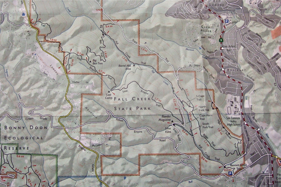
We started at the southern end of the park at the Bennett Creek Trailhead, hiking down the Bennett Creek Trail, then up the Fall Creek Trail to the first junction with the Lime Kiln Trail. We turned left and climbed a short distance upstream to the old Lime Kilns. We continued up the Cape Horn Trail past the Powder Magazine to the unmarked junction with the Lost Empire Trail where the major climbing began.
We climbed steeply uphill for some distance before the trail leveled-off, stopping briefly at the Lost Camp, where there was not much to be seen, and pressing upward again to the Big Ben Tree where we stopped for lunch.
After lunch we descended the Big Ben Trail to the north and joined the Fall Creek Trail, where Steve got stung by a yellowjacket. We started to explore the Fall Creek Trail upstream, but fallen trees blocked our way, so we started the long, gradual descent down Fall Creek, passing many old mudslides, sunny glades created when multiple trees fell, babbling springs, and rushing cascades. Fall Creek was running voluminously.
We paused for a while at the Barrel Mill, started to explore an unmarked trail that seemed to climb up to the Ridge Trail north of Fall Creek (where poor Steve got stung again on the back--probably the same yellowjacket that had been trapped in his shirt), and crossed Fall Creek itself several times before reaching the southern end of the park again and the short climb up Bennett Creek Trail to the trailhead.
Distance: 7.6 miles
Climbing: 1800 feet
Exposure mode: program (auto)
Metering Mode: matrix
Exposure time: 0.0067 s (1/150)
Aperture: f/2.8
Focal length: 8.0mm (35mm equivalent: 37mm)
ISO: 800
Flash: No
File size: 2905283 bytes
Camera maker: FUJIFILM
Camera model: FinePix F10
Resolution: 2718 x 1813
Page 1 / 35